3V Premana-Laghitt
Advanced 3V Premana-Laghitt
DEPARTURE/ARRIVAL
From: Giabio, Premana
To: Laghitt
TYPE/PERIOD
E-mtb
Autumn / Summer / Spring
Duration/Length
4 hours
12.50 km
CHANGE IN ALTITUDE
Uphill: 1169 m
DIFFICULTY
Advanced

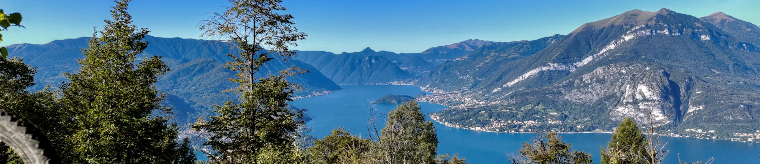
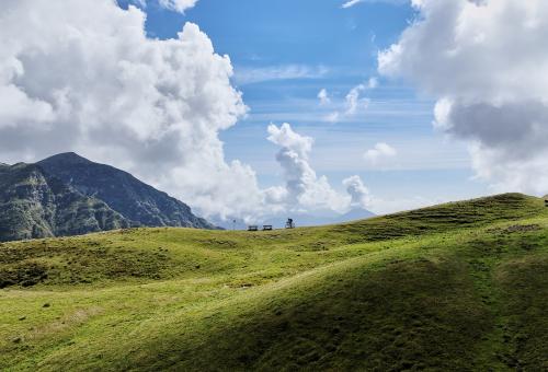
Route suitable for those using electric bikes (e-mtb) on off-road and trails with very challenging climbs. The starting point is Premana, from here climb to the Laghitt through the Varrone Torrent Valley from the locality Giabbio di Premana, where it is possible to arrive by car and park. The route starts from the parking lot of the Premana craft area, where the mule track begins, following the Varrone stream up the entire valley to Bocchetta di Trona, also called the "iron road" because of the presence of ancient mines. The ride passes by a sign indicating the Casera Vecchia di Varrone hut at 9 km. Among old mountain huts, you pedal on level ground to the left of the Varrone stream and cross the first stone bridge. The road alternates between dirt and concrete-bottomed sections. You arrive at the Giabi farmhouse, where there is a fountain; immediately after passing another stone bridge you return to the left of the stream. From here you begin to climb into a deciduous forest. Valvarrone is best known for the various mountain pastures that you cross along the way: Alpe dei Forni, Vegessa and Casarsa. After passing more hairpin bends, you arrive at Forni di Sopra (m. 1105) where the road in this section is well paved until the hamlet of Vegessa (m. 1200). At the beginning of the hamlet there is a fork in the road; keeping to the left and passing by a cross, you come to a madonnina and a fountain. Passing the last houses there is a picnic area, then continue passing in the vicinity of the Dente Waterfall where the mule track quickly climbs the valley with a few hairpin bends, after which you take the fork on the right to enter a path halfway up the mountainside with wide up and down sections in the forest. From this point the ascent becomes technical, and the trail requires good riding skills. The beech, pine and larch forests are of value, leading to Alpe Artino. From here it is possible to continue up the slope to Malga Alpe Artino for a break, or turn left and continue the ascent on trail. Do not forget to bring water as the trail does not have many landmarks. Almost at the end of the trail, after a series of uphill passages on switchbacks, you will reach the Donkey Lake, then the Laghitt destination, which offers spectacular views up to the Biandino Ridge. From here it is possible to continue to Val Biandino in the direction of Pizzo dei Tre Signori or to Piani delle Betulle following the Cresta di Biandino to Larice Bruciato and Cimone di Margno.

Cities crossed by the itinerary

Watch the itinerary video

Fotogallery

Sentiero per l'alpe Artino
Sentiero per i Laghitt
Strada per Varrone
Strada Forni di sopra-Varrone
Laghetto degli asini
Sentiero per i Laghitt

Point of Interest

Itinerary Data

hedaer

A new cycle network has been created in the Upper Lake Como area. There are 23 routes in two large areas along the lake's shores, for a total of 380 kilometers. Two routes are for beginners, 10 for intermediates, 8 for advanced cyclists, and 3 for experts. The difficulty scale and route tracking were verified by CAI experts, and an international evaluation standard was adopted in agreement with the Lombardy Region.


Along the routes, there are many panoramic points where you can admire the stunning beauty of Lake Como. The app provides all the information you need to safely navigate the routes, including directions to equipped areas, places of art and culture to visit, and events scheduled in the towns along the chosen route. You can also watch videos of the best panoramic views.


THE CYCLE ROUTES OF THE WESTERN NORTH LAKE COMO - There are 8 new routes at mid-mountain and high altitude, for a total length of 134 kilometers. The routes connect to existing connections between mountain towns and lakeside towns, where there is already a cycle path. The routes start in Sorico and pass through Montemezzo, Vercana, Trezzone, Livo, Peglio, Dosso del Liro, Gravedona ed Uniti, Stazzona, Dongo, Garzeno, Pianello del Lario, Musso, and end in Cremia.


THE CYCLE ROUTES IN THE VALSASSINA - There are 15 routes that allow you to climb from the lake to the Valsassina and Valvarrone, taking advantage of the trails on Mount Legnoncino; the loop circuits in the North Valsassina; the connections with the Valsassina cycle path; and the routes of the Val d'Esino.


WHAT ARE INTERNAL AREAS AND THE "UPPER LAKE COMO AND VALLI DEL LARIO" STRATEGY? - The "North Lake Como and Valli del Lario" Area Strategy was launched in 2018 as part of the National Strategy for Internal Areas 2014/2020. It involved 31 municipalities in the Valsassina, Valvarrone, Val d'Esino, and Riviera (Lecco) communities and the Valli del Lario and Ceresio communities (Como). The National Strategy for Internal Areas (SNAI) is a strategic plan designed to enhance and develop internal areas, which are often characterized by challenges such as depopulation, lack of services, and fewer economic opportunities. The goal is to promote the sustainable development of these areas by investing in infrastructure, services, the local economy, and the preservation of cultural and natural resources. The "Upper Lake Como and Valli del Lario" Area Strategy, implemented in the period 2018/2023, has made it possible to implement 31 projects for a total of 20 million euros, of which 5,285,000 euros were used to promote interventions to recover and enhance the heritage and to strengthen the cycle and hiking routes between the lake and the valleys.

Install app

GO
What is a PWA? Progressive Web Apps are a hybrid of mobile app and Web site: it is a technology that runs on the browser and does not require downloads from the app store, which contains Web pages just like a site. Through the install command on the browser you can create a quick link on your smartphone.