Legnone
Expert T.O.2. Legnone
DEPARTURE/ARRIVAL
From: Delebio
To: Via Torre, 9, 23833 Pagnona LC, Italia
TYPE/PERIOD
Mountain Bike / Bike / E-mtb
Summer / Spring / Autumn
Duration/Length
10 hours
27.20 km
CHANGE IN ALTITUDE
Uphill: 2200 m
Downhill: 1560 m
DIFFICULTY
Expert

A long and challenging alpine itinerary that crosses the Monte Legnone massif, connecting the Valtellina with the Valvarrone. The route follows historical mule tracks and military roads built during the First World War, immersed in a severe and spectacular alpine environment. It is designed for experienced hikers and highly trained cyclists, fully aware of the technical and physical demands of high-altitude trails.

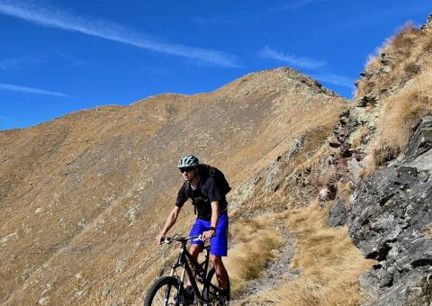
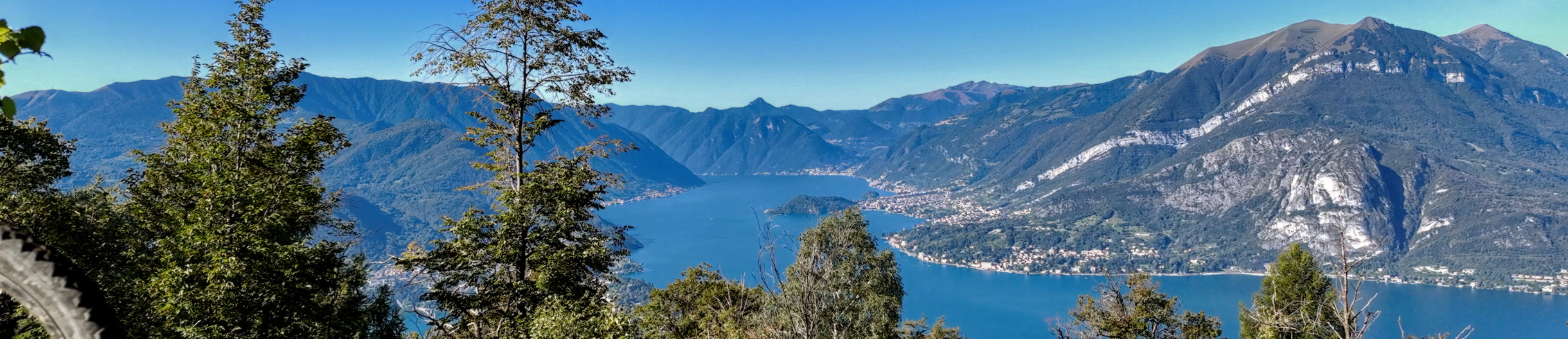
The route starts from Delebio, ascending the Val Lesina, the first Orobic valley at the entrance to Valtellina. The climb follows forest and pasture roads as well as ancient mule tracks, passing through the hamlets of Ossiccio di Sotto, Ossiccio di Sopra, Canargo, and Piazza Calda, before continuing with long diagonals below the northern ridge of Monte Legnone. Upon reaching Corte della Galida (Pansun), the trail enters the high-altitude environment. From here, the route proceeds toward Alpe Cappello, crossing wide panoramic pastures overlooking the Orobie Alps and the Val Lesina. It then continues to Alpe Legnone, where the Rifugio Legnone (1,696 m) is located on a large grassy terrace dominated by a tall wooden cross. The refuge is a strategic hub of the itinerary: a stopover and overnight point, as well as a key junction for high-altitude connections between the Valtellina and Lake Como sides. From Rifugio Legnone, it is possible to continue toward Rifugio Scoggione, following the historical military roads that cross high pastures and slopes. This connection, adapted to facilitate MTB traffic, allows for the creation of highly scenic circular routes. From Scoggione and the Baita del Lago, the trail ascends toward Monte Colombano (2,008 m), an important natural viewpoint and junction of the military paths. Here begins the main north-to-south traverse of the Legnone massif, progressively gaining higher elevations. The route reaches the Bocchetta del Legnone (approximately 2,395 m), the highest point of the itinerary and a natural pass between Valtellina and Valvarrone. This long and demanding section is the most challenging part of the trail, with extensive exposed sectors and passages that require full attention. For MTB users, certain segments must be negotiated by pushing the bike due to trail exposure, steep gradients, and tight switchbacks. Special caution is required along the summit section, which crosses the Forcella Alta di Legnone up to the Matok del Petóo (2,305 m). From the pass, the trail descends along the southern slope toward the Valvarrone, initially technical and exposed, then gradually becoming more rideable along historical mule tracks. Passing by Rifugio Griera and crossing alpine pastures and forests, the route steadily loses altitude until reaching Provincial Road 67 and the village of Pagnona, the terminus of the main itinerary.

Cities crossed by the itinerary

Watch the itinerary video

Fotogallery

Salita dal lato Valtellinese
La vetta del Legnone sullo sfondo
Il Legnone
Il sedime
Dettagli
La Valtellina sullo sfondo
Dettagli e prospettive

Point of Interest

Itinerary Data

hedaer

A new cycle network has been created in the Upper Lake Como area. There are 23 routes in two large areas along the lake's shores, for a total of 380 kilometers. Two routes are for beginners, 10 for intermediates, 8 for advanced cyclists, and 3 for experts. The difficulty scale and route tracking were verified by CAI experts, and an international evaluation standard was adopted in agreement with the Lombardy Region.


Along the routes, there are many panoramic points where you can admire the stunning beauty of Lake Como. The app provides all the information you need to safely navigate the routes, including directions to equipped areas, places of art and culture to visit, and events scheduled in the towns along the chosen route. You can also watch videos of the best panoramic views.


THE CYCLE ROUTES OF THE WESTERN NORTH LAKE COMO - There are 8 new routes at mid-mountain and high altitude, for a total length of 134 kilometers. The routes connect to existing connections between mountain towns and lakeside towns, where there is already a cycle path. The routes start in Sorico and pass through Montemezzo, Vercana, Trezzone, Livo, Peglio, Dosso del Liro, Gravedona ed Uniti, Stazzona, Dongo, Garzeno, Pianello del Lario, Musso, and end in Cremia.


THE CYCLE ROUTES IN THE VALSASSINA - There are 15 routes that allow you to climb from the lake to the Valsassina and Valvarrone, taking advantage of the trails on Mount Legnoncino; the loop circuits in the North Valsassina; the connections with the Valsassina cycle path; and the routes of the Val d'Esino.


WHAT ARE INTERNAL AREAS AND THE "UPPER LAKE COMO AND VALLI DEL LARIO" STRATEGY? - The "North Lake Como and Valli del Lario" Area Strategy was launched in 2018 as part of the National Strategy for Internal Areas 2014/2020. It involved 31 municipalities in the Valsassina, Valvarrone, Val d'Esino, and Riviera (Lecco) communities and the Valli del Lario and Ceresio communities (Como). The National Strategy for Internal Areas (SNAI) is a strategic plan designed to enhance and develop internal areas, which are often characterized by challenges such as depopulation, lack of services, and fewer economic opportunities. The goal is to promote the sustainable development of these areas by investing in infrastructure, services, the local economy, and the preservation of cultural and natural resources. The "Upper Lake Como and Valli del Lario" Area Strategy, implemented in the period 2018/2023, has made it possible to implement 31 projects for a total of 20 million euros, of which 5,285,000 euros were used to promote interventions to recover and enhance the heritage and to strengthen the cycle and hiking routes between the lake and the valleys.

Install app

GO
What is a PWA? Progressive Web Apps are a hybrid of mobile app and Web site: it is a technology that runs on the browser and does not require downloads from the app store, which contains Web pages just like a site. Through the install command on the browser you can create a quick link on your smartphone.